

Welcome to your vacation apartment in Chalet Soldanella, with our central location we are the ideal starting point for hiking. Your hiking boots have their own place on a large shoe rack and are not in your way in the vacation apartment. After a long walk you can put your feet up on a deck chair in the garden while your hiking clothes do their rounds in our washing machine. Thanks to our wifi, you can plan a new tour at any time. And you can relax night after night on our quality mattresses. If you have any questions about the facilities in our apartments, you will find the answers here.
Hiking in Grächen – discover varied tours in Valais
Hiking in Grächen offers ideal conditions for anyone who wants to experience nature, exercise and panoramic views in Valais. The sunny mountain village is surrounded by an extensive network of hiking trails, ranging from easy walks to challenging mountain tours. The region above the Mattertal valley is known for its well-maintained paths, scenic routes and varied landscape with alpine pastures, forests and high-altitude trails. Thanks to clear signposting and good planning with a Grächen hiking map, hikes can be planned safely and individually.
Grächen hiking for beginners, families and pleasure hikers
Grächen is ideal for beginners, families and anyone who wants to enjoy a relaxed hike. Many paths are moderate, well-maintained and offer numerous rest areas and viewpoints. Particularly popular are themed trails and shorter circular walks, which are also easy to do with children. Pleasure hikers appreciate the combination of easy stages, beautiful nature and refreshment stops along the way. These hikes allow you to discover Grächen at a leisurely pace and enjoy the alpine surroundings without too much physical exertion.
Important points:
- Easy to moderately difficult hiking trails
- Family-friendly routes and themed trails
- Many rest areas and viewpoints
Challenging hikes around Grächen for experienced hikers
Experienced hikers will also find numerous challenging tours around Grächen. These routes cover longer distances, sometimes involve greater differences in altitude and run through alpine terrain. High-altitude trails and connecting routes to neighboring regions offer impressive panoramic views of the Valais Alps. A good level of fitness, sure-footedness and careful planning are essential for such tours. A detailed Grächen hiking map or digital navigation will help you to realistically estimate the stages and stay safe on the trail.
Highlights for experienced hikers:
- Longer day hikes with elevation gain
- High trails with a wide panorama
- Alpine routes with varied terrain
Hiking in Grächen in summer – nature, panorama and alpine pastures
In summer, Grächen shows its particularly diverse side. Lush alpine meadows, blooming mountain flora and clear views characterize the hiking experience. The warm months are ideal for extended tours or for combining leisurely hikes with breaks on alpine pastures and sun terraces. Many paths lead through open landscapes and offer impressive views of the surrounding mountains. With an up-to-date hiking map of Grächen, summer hikes can be optimally planned and adapted to the weather and fitness level.
Summer highlights:
- Refreshment stops along the routes
- blooming alpine pastures and mountain meadows
- Panoramic trails with far-reaching views
Grächen hiking map – orientation and planning for every tour
The Grächen hiking map is a key aid for anyone who wants to plan their hikes carefully. It shows the complete network of trails in the region with distances, altitudes and levels of difficulty. Whether it’s a short circular hike, a day’s stage or a longer mountain tour, the hiking map provides a clear overview of possible routes and connecting paths. In addition to printed maps, digital versions are also available to provide additional safety and orientation along the way.
What does the Grächen hiking map show and how do you use it correctly?
The Grächen hiking map contains all the important information for safe tour planning. This includes marked hiking trails, altitude profiles as well as information on rest areas and connections to mountain railroads. Before setting off, you should study the route carefully and realistically assess your own fitness level. During the hike, the map helps you to correctly identify junctions and keep track of the route.
Tips for use:
- Fully plan your route in advance
- Consider altitude and walking time
- Use a combination of card and smartphone
Grächen hiking map for day hikes and multi-day tours
For day hikes, the Grächen hiking map shows numerous routes that can be easily combined and vary in duration and difficulty. Multi-day tours can also be prepared by taking stages, altitude profiles and possible rest points into account. Good planning is particularly important for longer tours in order to combine routes sensibly and avoid overexertion. The hiking map helps you to choose realistic stages and plan the day’s route in the best possible way.
Tips for planning tours with the Grächen hiking map
Good tour planning increases safety and enjoyment when hiking in Grächen. In addition to choosing the right route, weather conditions, length of day and personal experience should be taken into account. The hiking map helps you to determine your start and destination and plan alternative routes.
- Compare tour length and level of difficulty
- Pay attention to the weather and season
- Plan breaks and return journeys
With the right map and good preparation, the hiking route and course of the day can be optimally coordinated, regardless of whether you are planning a short hike or an extended tour.
Here is a small selection of hikes
Grächen culture: Village tour
Grächen Tourismus: To the lake – Hohtschuggi
Grächen Tourism: Riedgletscher
Grächen Tourismus: Hannigalp circular hike
Grächen Tourismus: Overview hiking time
Grächen Tourismus: Boys – Moosalp
Zermatt Tourism: 5 Lakes Trail
From Grächen to the Matterhorn: day trip to Zermatt with a 30% discount
Summer months and the diversity of hiking
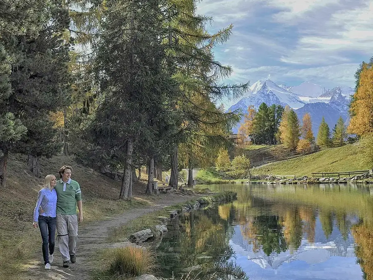
Flowering plants, lush mountain meadows and the gentle lapping of the water – the idyllic picture that is probably unfolding in your mind right now is exactly what you can experience here with us. Whether at our picturesque mountain lake, along the historic water pipes (Suonen), which have been carrying water to the fields and pastures for over 400 years, or at the majestic glacier gate of the Ried Glacier – here you can experience nature and geotourism in their purest form. Grächen offers a variety of easy hiking trails that are also accessible with baby carriages, as well as themed trails suitable for all ages.
The tours to our two nearest huts also offer special hiking experiences: the SAC Bordierhütte, which can be reached from Chalet Soldanella in 8 km and around 5 hours on foot with a difference in altitude of 1200 meters, and the SAC Topali Hut, which can be reached from St. Niklaus in 7 km and also 5 hours on foot with a difference in altitude of 1550 meters. The feeling of happiness when you reach the top, the breathtaking view of 14 four-thousand-metre peaks and the close proximity to nature make up for any effort.
With a total of 250 kilometers of hiking trails in and around Grächen, you are sure to find a favorite spot that is second to none. One of our personal favorites is the Alpe Jungen, located on the other side of the valley from Chalet Soldanella. Such an idyllic and tranquil spot in the midst of the hectic and fast-paced world of today is something very special. From Moosalp, you can reach Alpe Jungen in around 4 hours via the high-altitude trail. Alternatively, you can get there comfortably from St. Niklaus by cable car in just 10 minutes.
If you feel the urge to explore the surrounding area during your stay, we can warmly recommend the area around Zermatt or the Aletsch region with the largest glacier in the Alps.
FAQ – Hiking in Grächen
Back to overview“Experience Grächen”